Tuesday, July 24, 2012

Tools to Study Hurricanes

Scientist and meteorologists use a lot of equipment and processes to provide information about hurricanes, how they form, their characteristics, and forecasts about where the storm may go. In May, 2011, Hunters Creek Elementary fifth grade students visited a hurricane hunter airplane. The students enjoyed a discussion with a meteorologist from NOAA, local emergency readiness officials, and a tour of the airplane. During the tour, the students spoke with onboard meteorologists and the planes's pilot.

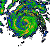
The Hurricane Hunter airplanes are very sophisticated aircraft assigned to fly into hurricanes to gather data about the storm. They release data gathering canisters containing sensors that relay information back to the meteorologists and scientists onboard the plane. These instruments are called dropsondes.  They are weather sensors that measure atmospheric pressure, temperature, and humidity.  The dropsonde uses a GPS to also help determine the wind in and around a hurricane.  As the probes fall through the storm at nearly 35 miles per hour it relays data back to the aircraft.  Over 50 dropsondes are released into a hurricane during each flight.


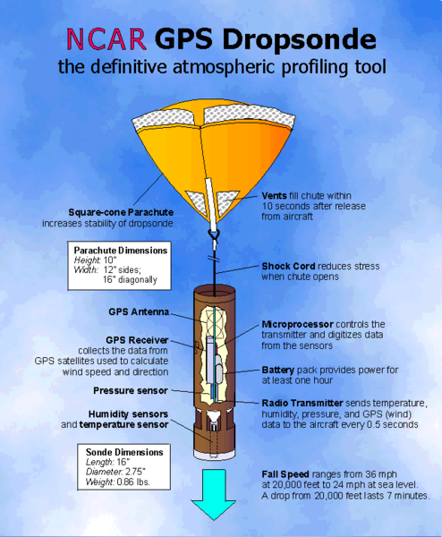
A dropsonde operator places the instrument inside a tube and sends it down a chute where it is released from the bottom of the aircraft.  A parachute opens to allow the instrument to float down while collecting and transmitting their data.

Stanitski, Diane Marie and John J. Adler, Teacher in the Air, Dr. Diane's Flight with the NOAA Hurricane Hunters.  National Oceanic and Atmospheric Administration, 2006. 

Dropsonde image from: rvanews.com

Thursday, July 19, 2012

Hurricane Katrina 2005

Hurricane Katrina slammed into Louisiana's Gulf Coast on 2005.  This satellite imagery shows how the hurricane moved across the Gulf of Mexico and eventually made landfall in the Louisiana/Mississippi area.

http://www.youtube.com/watch?v=p5EAQ5UjWxY

NOAA sate...

What is a hurricane?

A hurricane is an intense, rotating oceanic weather system that possesses maximum sustained winds exceeding 119 km/hr (74 mph). It forms and intensifies over tropical oceanic regions.  This kind of storm has several names.  Depending upon where you live, this tropical storm can be called a:

  • "hurricane" (the North Atlantic Ocean, the Northeast Pacific Ocean east of the dateline, or the South Pacific Ocean east of 160E)
  • "typhoon" (the Northwest Pacific Ocean west of the dateline)
  • "severe tropical cyclone" or "Category 3 cyclone" and above (the Southwest Pacific Ocean west of 160°E or Southeast Indian Ocean east of 90°E)
  • "very severe cyclonic storm" (the North Indian Ocean)
  • "tropical cyclone" (the Southwest Indian Ocean)

Thanks to NOAA for help with this information.  The NOAAA website address is:  http://www.aoml.noaa.gov/hrd/tcfaq/A1.html

Hurricane


We have made it to mid-July and there are no tropical systems threatening the east coast.  We are simply dealing with excessive heat and little rain.